YouTube Flying Videos by Jan
Nademlejnsky
>> HOME <<
January 5, 2026
| 2026 | 2025 |
2024 | 2023 | 2022 | 2021 | 2020 | 2019 | 2018 | 2017 | 2016 | 2015 | 2014 | 2013 | 2012 | 1974-2010 | Video Index |
You could search this page by
pressing Crl F
| BC Fires | My Tubespace |
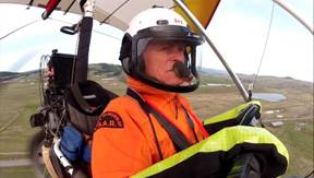
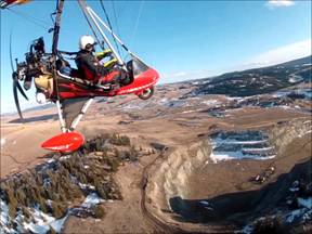
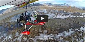
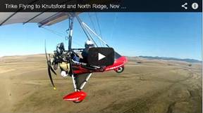 84. Trike
Flying to Knutsford and North Ridge, Nov 12, 2014
84. Trike
Flying to Knutsford and North Ridge, Nov 12, 2014
This was first, really cold day in
After short chat with my fellow pilot and with another
gloves on, I took off towards
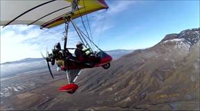
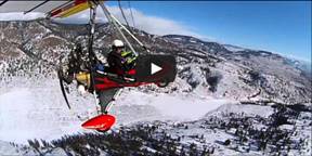
 83. Good
Flying Day, Nov 2, 2014
83. Good
Flying Day, Nov 2, 2014
Weather was forecasted as one of the still relatively warm
days. I had to do it. Flew over the famous North Thompson river sand bars, then
river upstream towards
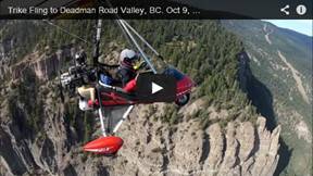 82. Trike
Flying to Deadman Road Valley, BC. Oct 9, 2014
82. Trike
Flying to Deadman Road Valley, BC. Oct 9, 2014
This was one of the best and the most beautiful
flights. The flight took 2 hours to cover 140 km, through extremely beautiful
mountain valley. Leaves were in full colors in spectacular scenery. I
encountered several very heavy turbulences, but I had fun with them. I explored
that region the following week from the road. It is definitively very beautiful
area.
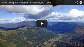 81. Trike
Flying to Ski Resort Sunpeaks, BC. Oct 8, 2014
81. Trike
Flying to Ski Resort Sunpeaks, BC. Oct 8, 2014
It was my true first cross country mountain flying
through potentially very hostile and quickly changing weather conditions. The
weather was perfect, but still with occasional heavy turbulence. Eventually I
enjoyed those challenging flying conditions and even sought some thermals under
mountain clouds. I gained a lot of confidence. I had to repeat this experience
the next day with flying another mountain cross country.
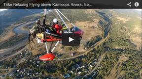 80. Trike
Relaxing Flying above Kamloops Rivers, Sep 28, 2014
80. Trike
Relaxing Flying above Kamloops Rivers, Sep 28, 2014
It was very unusually turbulence free day for very
relaxing flying above and along the South and North Thompson rivers. The
visibility was not the best and especially the low sun position on the western
horizon did not help either.
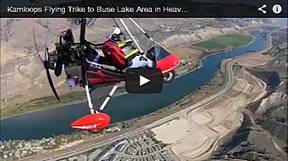 79. Kamloops
Flying Trike to Buse Lake Area in Heavy Turbulent Air, Sept 12, 2014
79. Kamloops
Flying Trike to Buse Lake Area in Heavy Turbulent Air, Sept 12, 2014
It was beautiful, a bit crispy day with no wind, while
sun heat started to slowly change the tranquility of the still air. Originally
my flying goal was much more ambitious, but turbulence did not allow me to
reach it. It was getting unpleasant and fear of air sickness was very real for
me. I was pushing my comfort envelope with hope that I will have very good
video from my bumpy experience. I was not disappointed from this aspect. You
could see from the video how the terrain is complex below and around, and how
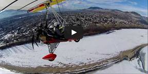
many potential sources of thermals and downdrafts are there.
I used special post processing software, where the
video from the wing camera is transformed into more realistic viewers
experience. Instead of background moving around and the trike stationary in one
place on screen, the software reverses it. The trike is realistically moving in
the air and the background is relatively steady. It looks like someone else
took the video of me. It is very tedious process, taking hours, but very cool
effect.
I speeded up some sections up to 4x to show the
beauty, but eliminated boringness of the normal speed flying, which sometimes
looks like I was stationary there.
 78. Trike
Flying to Tranquille Farms, North Ridge and Thompson River Sand Bars, Aug 31,
2014
78. Trike
Flying to Tranquille Farms, North Ridge and Thompson River Sand Bars, Aug 31,
2014
I flew west over Tranquille farm to take pictures of
newly created corn maze. Continued NW over the
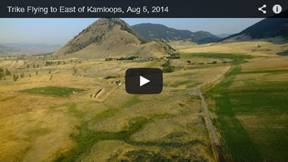 77. Trike
Flying to East of Kamloops, Aug 5, 2014
77. Trike
Flying to East of Kamloops, Aug 5, 2014
Early morning flight in smoky sky from BC forest
fires, following South Thompson River East. Very tranquil flight up to the last
minutes. It was turbulent above city on the way back. Strong sun heat created
many local up and down drafts based on the ground colors. Overall it was very
good flight.
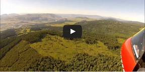
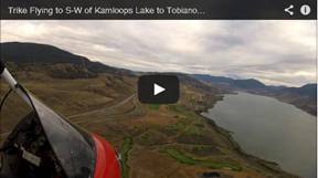 76.
Trike Flying to S-W of Kamloops Lake to
Tobiano Golf Course, July 25, 2014
76.
Trike Flying to S-W of Kamloops Lake to
Tobiano Golf Course, July 25, 2014
Just short, 50 min flight to get my flying fix.
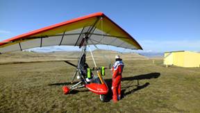
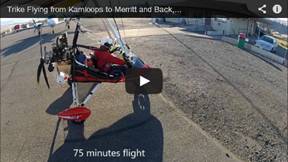 75. Trike
Flying from Kamloops to Merritt and Back, July 12, 2014
75. Trike
Flying from Kamloops to Merritt and Back, July 12, 2014
I was thinking about this flight for a long time. I
was watching very carefully the strange
I felt almost like Lindberg when he decided to fly
solo across the ocean from
I was ready to take off at 5:45 am. It was just 19C,
which was very pleasant compare with those 40C hot days. It took a lot of
pushing "up hill" from 1100' to 6000" to cross the mountain
peaks. I do not like to rev up my Rotax 582 too much, which I no not think it
is healthy for it.
I was following more-less the
Coquihalla highway, the famous highway from Discovery channel series Highway Thru Hell.
Government in July of this
year increased speed limit there to 120 km/h. This was met with very vocal
opposition, because it is dangerous, people will die and all this normal
nonsense. I was ready to document all those dead people and vehicle pile ups
along the highway. Fortunately and of course there was nothing of this gore
stuff to photograph.
The weather was perfect, no wind and no turbulence,
which does not happen very often here. I landed in Merritt Municipal airport
(2090') after 75 min flight. Took some pictures, refuelled from my spare fuel can,
and took off again further south towards Merritt town. I did not spend too much
time there, because I wanted to enjoy the same perfect weather on the way back.
It was already 25C, so the heat was on...
I was enjoying the scenery even though the visibility
was not the best. It was actually the first day this summer with hazy sky. The
flight was very uneventful and I was almost day dreaming when suddenly I
received several jolts of unexpected turbulence. I still had about 30 min to go
so I was hoping that this will not be my fun spoiler. Luckily it lasted just
about 5 minutes, but I decided not to go exploring, but head straight home. In
45 minutes of in bound leg flying I was back at the
This was my milestone flight, the longest
cross-country so far.
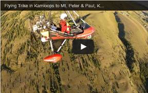 74. Flying
Trike in Kamloops to Mt. Peter & Paul, Knutsford, Ajax Mine, June 30, 2014
74. Flying
Trike in Kamloops to Mt. Peter & Paul, Knutsford, Ajax Mine, June 30, 2014
It was one of the best flying
days. Warm, no wind and no turbulence, which is very rare combination. Flew
over
 73. Flying
Trike to O'Connor Lake, NE of Kamloops, June 22, 2014
73. Flying
Trike to O'Connor Lake, NE of Kamloops, June 22, 2014
This Sunday morning was
perfect day to do some flying. Checked the flooded areas near Tranquille Farm
and then turned East and eventually NE to follow
 72. Flying
Trike in Knutsford Mt Peter and Paul, North Ridge Grasslands Park, May 14, 2014
72. Flying
Trike in Knutsford Mt Peter and Paul, North Ridge Grasslands Park, May 14, 2014
Warm morning was ideal time
for some fun flying. Flew North to Knutsford airstrip then South around and
above of Mt Peter and Paul. Did some low flying over the North Ridge "Lac
Du Bois Grasslands Park" which is very beautiful place.
 71. Flying
Trike in Kamloops NW Ridge, May 7, 2014
71. Flying
Trike in Kamloops NW Ridge, May 7, 2014
It was beautiful weather with
almost no wind. Turbulence grabbed me as soon as I was air borne. I fought it
for several minutes, but eventually gave up, because it was dangerous. I was
back in my hangar in just 5 min, where I discovered that I forgot to turn my
video cameras on.
Tried again in the in the evening and it was fun.
Explored NW of North Ridge where I had to stay due to skydivers activities in
the NE region. Tested Garmin sport camera "VIRBelite" which I forgot
to set in the same format as the other two GoPro Hero2 cameras. It seems to me
that the stabilization of Garmin is better and it appears that it stabilizes
background (horizon) and the trike is moving as this is how it supposed to be.
I do the same with my GoPro camera in very lengthy and time consuming process
with Muvee TVS (see http://youtu.be/GT1MQhoJxK8
for explanation). GoPro has overall better and more natural colors. Garmin
colors are bluish especially under contrast or low light conditions.
 70. Flying
Trike to NW of Kamloops North Ridge with Power OFF Glide, April 25, 2014
70. Flying
Trike to NW of Kamloops North Ridge with Power OFF Glide, April 25, 2014
Flew to NW of beautiful region
of Kamloops North Mountain Ridge with spectacular view of 150 m deep
 69. Flying
Trike to Knutsford, Rose Hill and NE Mountain Ridge, Apr 5, 2014
69. Flying
Trike to Knutsford, Rose Hill and NE Mountain Ridge, Apr 5, 2014
I am getting better now in handling
turbulence. I came from
 68. Flying
Trike to Ajax Mine, Knutsford and Downtown, Mar 23, 2014
68. Flying
Trike to Ajax Mine, Knutsford and Downtown, Mar 23, 2014
It was very good day for flying. Check the
 67. Flying
Trike in Turbulent Air, South Ridge, Kamloops Mar 14, 2014
67. Flying
Trike in Turbulent Air, South Ridge, Kamloops Mar 14, 2014
Very light wind and ideal flying conditions at the airport
turned into 22 km headwind and unpleasant turbulence. Half way to my original
place to fly I had to turn back, because it was not fun to fight the elements.
The video shows the effect of turbulence on this light aircraft.
 66. Trike
Flying - Chasing Clouds in Kamloops, Mar 9 2014
66. Trike
Flying - Chasing Clouds in Kamloops, Mar 9 2014
It was very promising day for enjoyable flying. Low
clouds hanging above and around the peaks which I liked to explore. Flew east
following the North Mountain Ridge towards Mt Peter and Paul. Noticed that my
neck camera was low on juice, so I turn back to get fresh batteries. I
encountered some bumpy right around to Mt Paul. Flew NW of Kamloops Lake to
check the "Sediment Wall", which I discovered a few days earlier on
my hike. Did some low flying above the
 65. Flying
Trike around Mt Peter and Paul, Kamloops Feb 26, 2014
65. Flying
Trike around Mt Peter and Paul, Kamloops Feb 26, 2014
This was the first movie which I edited in updated
version of MovieMaker 2.6 for Windows 7. It allows to take default of GoPro HD
4:3 format (widest viewing angles in 1280x960), edit it and save it into the
same format. Up to now I always had to use several different packages. I like
4:3 format because you can see it perfectly on iPad which is in 4:3. Majority
of people watches YouTube videos on mobile devices which are mostly in 4:3
format. The industry is pushing 16:9 format, cameras follows and editing softwares
all ignores millions of mobile devices and the majority of users. The resulting
16:9 video viewed on iPad loses 25% of pictures with black stripes above and
below the video. I processed small section from the wing camera in Muvee Turbo
Video Stabilizer, which stabilizes background so the trike is moving instead,
normally and unnaturally other way around.
 64. Flying AirBorne Trike in Kamloops
in Heavy Turbulence, Feb 13, 2014, Version 2
64. Flying AirBorne Trike in Kamloops
in Heavy Turbulence, Feb 13, 2014, Version 2
I re-edited the previous version into 16:9 format. I
used 2 GoPro cameras at 4:3 format and ActioPro at 16:9, The original version
did not look good. I spent several days to fiddle with this nonsense. Millions
of people are using GoPro cameras which is set by default to 1280x960. It is
the best format for flyers, skiers, bikers, because it captures the most info.
Every other format is in camera cropped result. Majority of people watches the
YouTube videos on iPad and similar devices which is in 4x3 format. There is
nothing on the market (as far as I know) to just take HD 4:3 format, edit it
and save it into lossless original format. 16:9 is the best on TV, for minority
of YouTube watchers, 4:3 is the best for mobile devices, which is the majority
of people.
1. I processed ActionPro (wing camera) in Muvee Turbo
Video Stabilizer, which stabilizes background so the trike is moving instead,
normally and unnaturally other way around.
2. I used AVS Video Converter to Crop the upper
portion of video files from 2 GoPro cameras mounted on the control bars. I
changed it from 1280x960 to 1280x720 to have the same format like the wing
camera. I could set GoPro to 1280x720 in the first place, but there was very
good chance that it would crop wrong portion of the frame. I cannot see what
camera see, I just estimate the aim.
3. I used MovieMaker 2 (I am PC guy), which is very
simple, free and produces excellent video quality, but unfortunately, it is in
*.wmv format which is then butchered by YouTube by their conversion.
4. I then process complete video from MovieMaker in
It was very nice weather, almost no wind, just ideal
conditions for flying. I took off with 3 cameras mounted to get different
views. The tranquil conditions changed very quickly. As soon as I was over the North Mountain Ridge, the
turbulence started to bounce me around. It was still bearable, so I continued
to North. It got really bad. I was searching for some better conditions to go
higher, lower, in the valley, above valley... Nothing worked, but it was
getting increasingly worse. I was like garbage bag in the wind. Eventually I
made it back close to the airport, but my timing was wrong. I had to wait for 3
airplanes to land while I was kicked up and down like a yoyo. It was the most
scary flight so far.
Finally I could cross the airport to partially frozen
 63. Flying
AirBorne Trike in Kamloops in Heavy Turbulence, Feb 13, 2014
63. Flying
AirBorne Trike in Kamloops in Heavy Turbulence, Feb 13, 2014
It was very nice weather, almost no wind, just ideal
conditions for flying. Took off with 3 cameras mounted to get different views. The
tranquil conditions changed very quickly. As soon as I was over the North Mountain Ridge, the
turbulence started to bounce me around. It was still bearable, so I continued
to North. It got really bad. I was searching for some better conditions to go higher,
lower, in the valley, above valley... Nothing worked, but it was getting
increasingly worse. I was like garbage bag in the wind. Eventually I made it
back close to the airport, but my timing was wrong. I had to wait for 3
airplanes to land while I was kicked up and down like a yoyo. It was the most
scary flight so far.
Finally I could cross the airport to partially frozen
 62. Flying
AirBorne Trike in Kamloops, North West Mountain Ridge, Feb 12, 2014
62. Flying
AirBorne Trike in Kamloops, North West Mountain Ridge, Feb 12, 2014
Finally, after month and half of unusually cold
weather in